

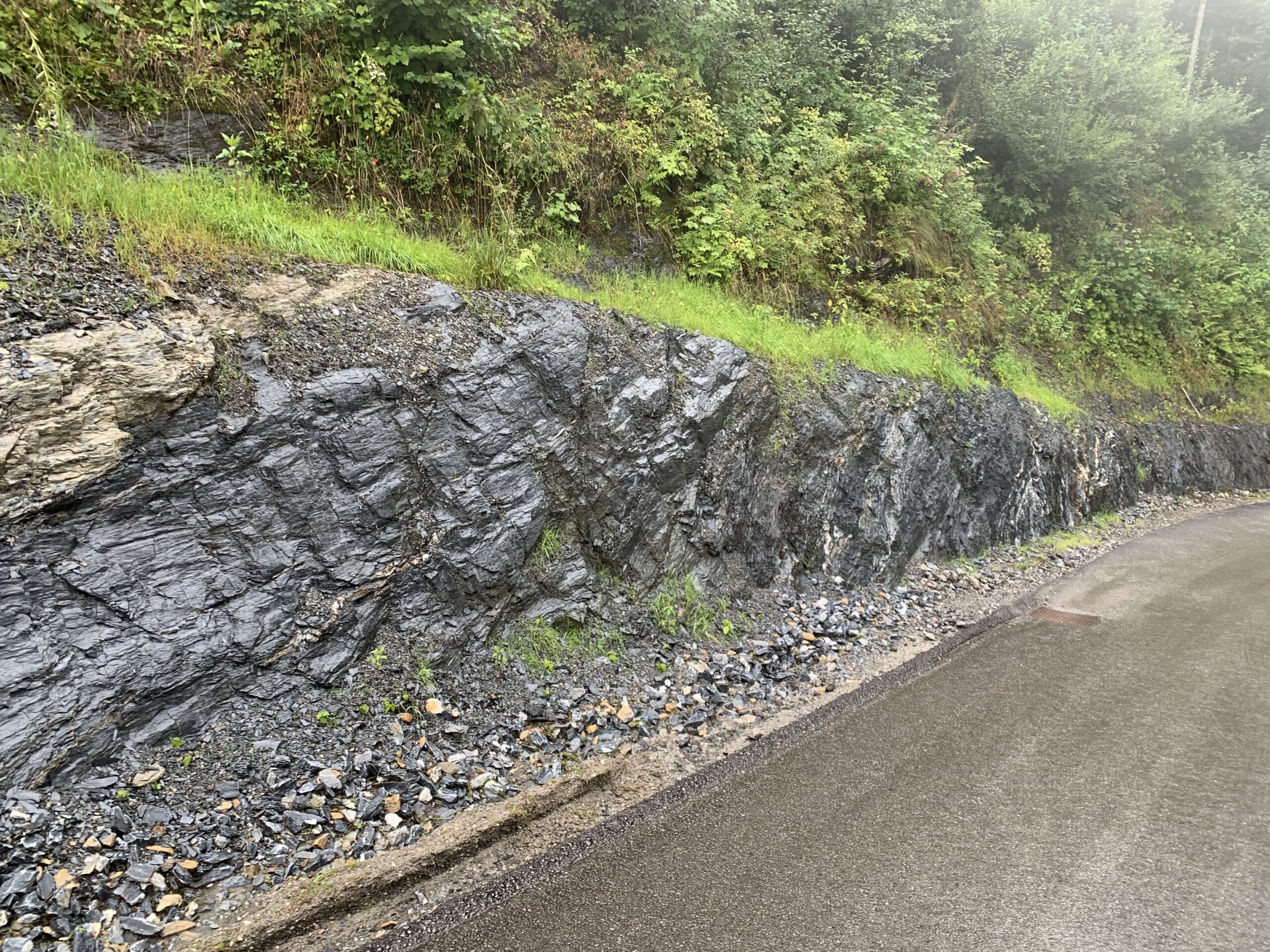
Greywacke Zone
The roadcut displays a very nice alternation between Schwarzphyllites and light phyllites of the Greywacke Zone. The Schwarzphyllites originated from dark, clayey sediments of an ocean basin. The dark color is attributed to organic components (dead plants or
microorganisms).
The light phyllites also originated from sediments of an ocean basin, but without organic substance and with a higher sand content, both indicative of originally coastal deposits.
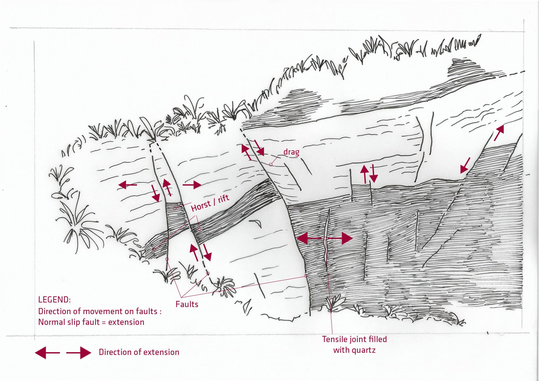
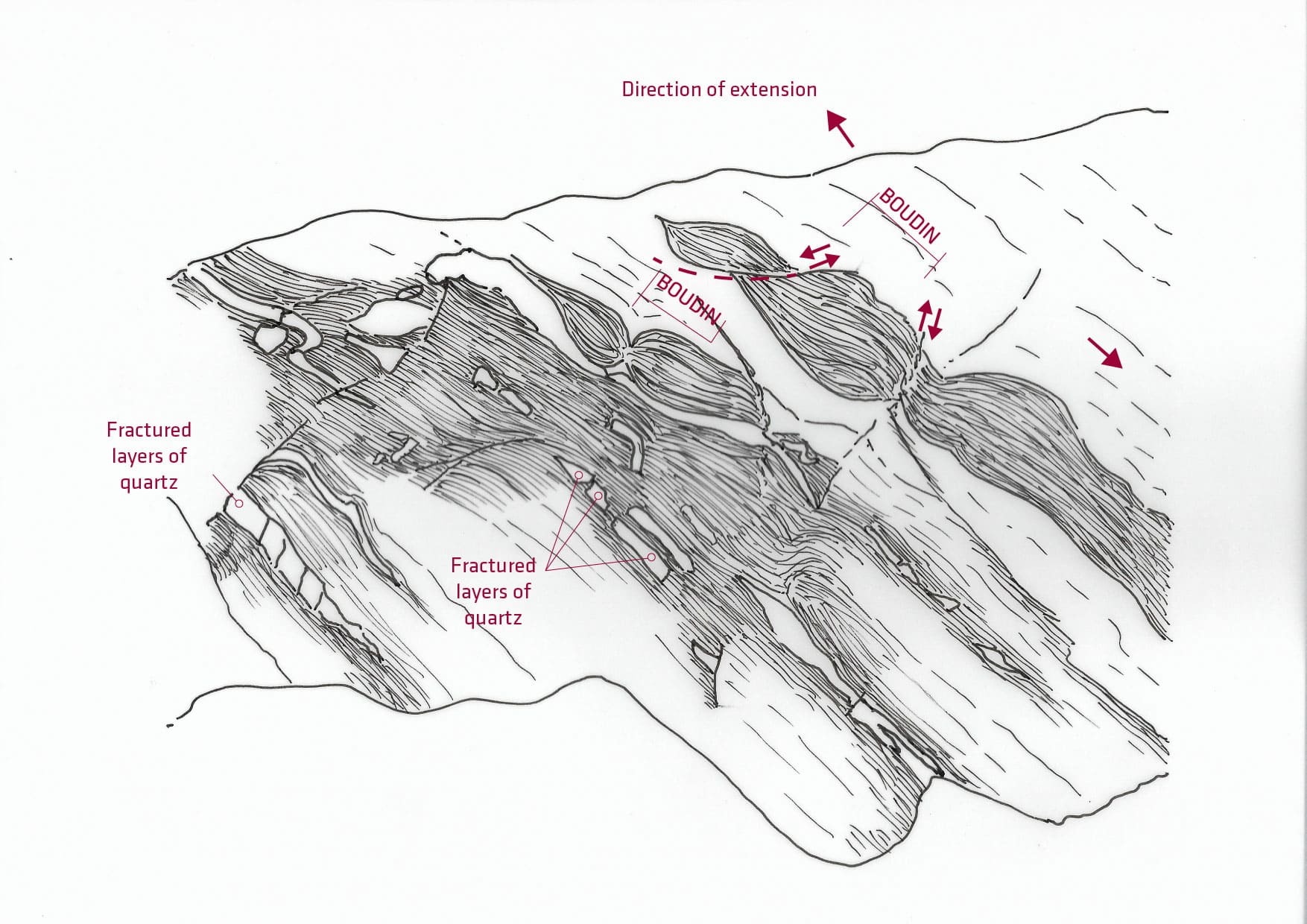
Several faults offset the phyllite in the form of so-called Horst-and-graden structures. The bending of the foliation surface ("dragging") also indicates the direction of movement. All faults are normal faults, movements caused by extension. Similar, the quartz-filled extensional fractures can be understood. These also resulted from extension, but higher temperatures (approxmiately 300 degrees Celsius).
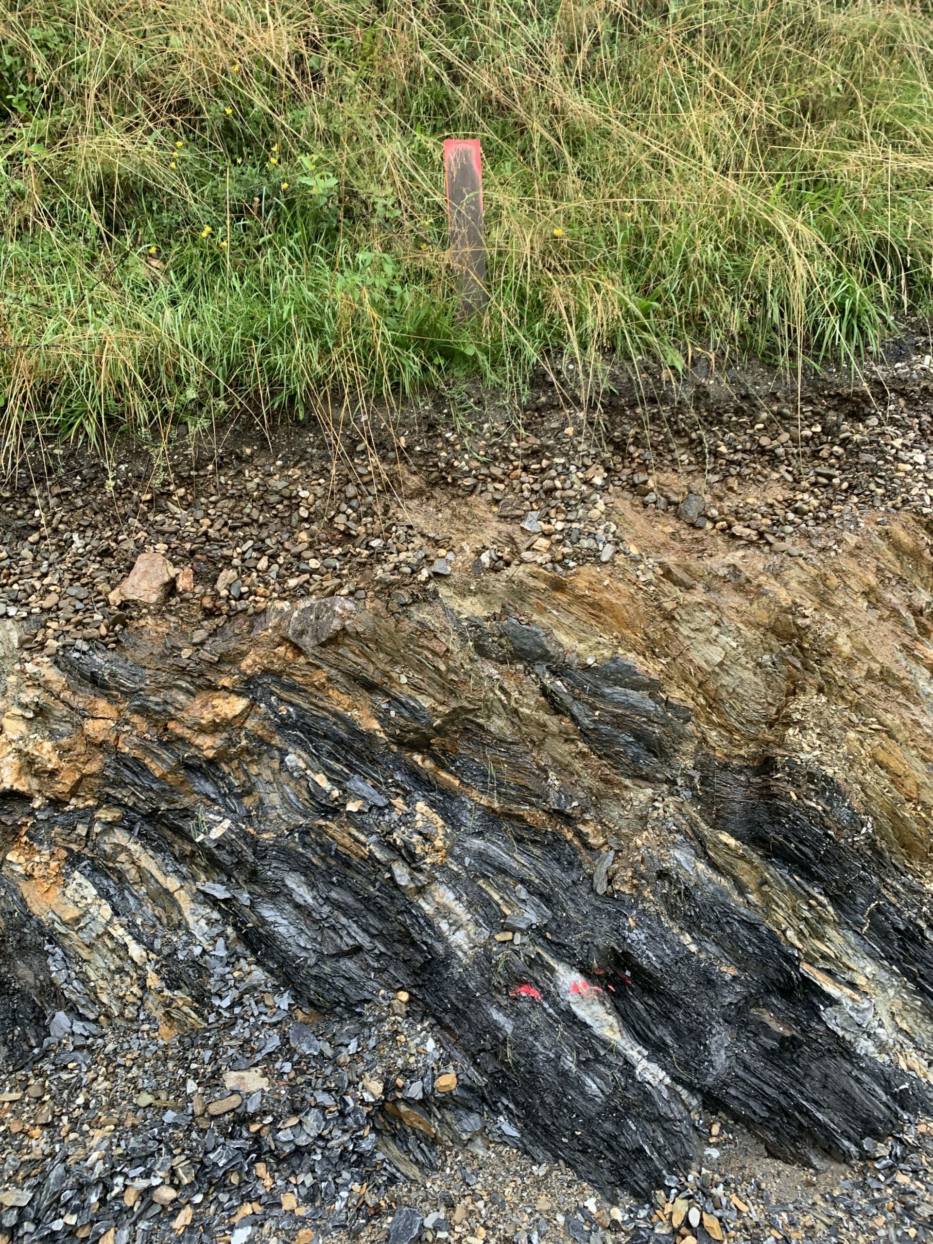
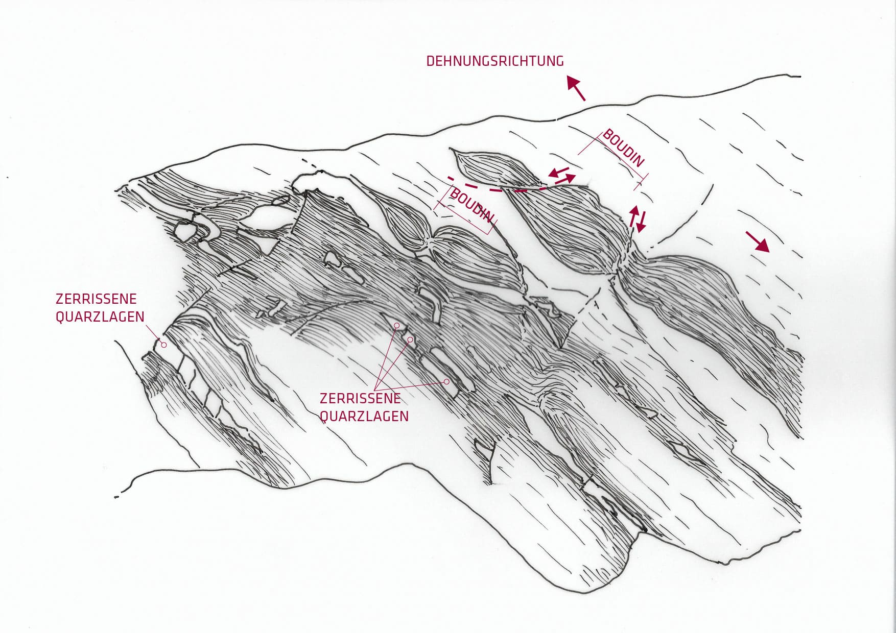
The alternation between Schwarzphyllites and light phyllites exhibits different extensional structures:
- Quartz-rich layers that have been torn apart
- So-called boudins (from French „boudin" for blood sausage), which form due to the ex- tension of layered rocks. Here, the dark layers break down into typical ellipsoidal shapes
surrounded by the surrounding light phyllite.

Kids
What is plate tectonics?
Stand still and concentrate on the ground beneath your feet! Can you feel the earth moving?
Probably not, because the Earth moves so slowly that we don't normally feel or see it! But we know that the earth doesn't just stand still: In many parts of the world, strong earthquakes and volcanic eruptions occur from time to time. All the rocks and landforms around you are also evidence of this constant movement; they have been formed over millions of years by small and large movements!
Of course, rocks and landforms are not living things, so how do they move?
Imagine the earth as a giant cake made up of different layers with different behaviours! The outermost layer is thin and solid - like a rock. But underneath is a layer of warm, molten rock that "piggybacks" the outer layer and moves it around! You can also think of the hard layer as pieces of ice floating on the water!
This concept of an actively moving earth is a theory called plate tectonics. The word tectonics comes from the Greek and means "to build up". Plate tectonics states that the Earth's outer layer of rock is divided into huge plates that contain landforms and bodies of water. When the plates move towards or away from each other, amazing processes take place on Earth, creating mountains, volcanoes, islands and ocean basins!
The movement of the plates is generally very slow and amounts to between 0.60 cm and 10 cm per year. That's why we can neither see nor feel them! Imagine how long it must have taken for the Alps to form!
What is plate tectonics?
Stand still and concentrate on the ground beneath your feet! Can you feel the earth moving?
Probably not, because the Earth moves so slowly that we don't normally feel or see it! But we know that the earth doesn't just stand still: In many parts of the world, strong earthquakes and volcanic eruptions occur from time to time. All the rocks and landforms around you are also evidence of this constant movement; they have been formed over millions of years by small and large movements!
Of course, rocks and landforms are not living things, so how can they move?
This concept of a dynamic Earth is a theory called plate tectonics, which was only developed in the 1960s! The word tectonics comes from the Greek and means "to build up". Plate tectonics states that the rigid, outer layer of the Earth - the lithosphere - is divided into moving plates that lie above a weaker, molten layer, the asthenosphere. The heat from the asthenosphere generates convection currents that drive the movement of the overlying plates.
The movement and interaction of these plates leads to the formation of large mountain belts, volcanoes and ocean basins. Much of the action takes place along their boundaries, where the plates either move towards each other (convergence), away from each other (divergence) or simply slide past each other (transform boundary)!
Divergence boundaries create new materials on the Earth's surface. Most of them are located along ridges deep in the ocean floor where magma rises. That's right, there are volcanic eruptions under the ocean! Divergent boundaries can also occur within continents, such as the East African Rift!
Convergent boundaries, on the other hand, are destructive zones where heavier lithosphere sinks beneath another or subducts towards the Earth's mantle. Many of these convergent boundaries - known as subduction zones - are located at the edges of the oceans, along structures known as trenches, where they meet the continents or land masses. This type of convergence has created volcanic islands, such as Japan and the Philippines, and long volcanic chains within continents, such as the Andes.
Another type of convergent boundary is the collision between lithospheres that are both light or buoyant. Instead of subducting, the lithospheric materials are "squeezed" and stacked on top of each other, creating broad mountain belts like the Alps!
Plate movement is generally very slow and amounts to between 0.60 cm and 10 cm per year. That's why we can neither see nor feel it! So imagine how long it must have taken for the Alps to form!
What is plate tectonics?
Until the 1960s, most geoscientists believed that oceans and continents had a fixed geographical position. However, the discovery of several lines of evidence pointed to the opposite: a dynamic Earth that is constantly in motion. We know this from earthquakes occurring in the deep-sea trenches, from an extensive system of seafloor ridges from which new material is created, and from active volcanism unevenly distributed across the world! All these developments led to a unifying theory of geology: plate tectonics!
Plate tectonics states that the Earth's rigid lithosphere - which consists of the crust and the solid parts of the upper mantle - is divided into several plates that float on the weaker, molten asthenosphere. The heat in the asthenosphere generates convection currents that move the overlying plates.
The movement and interactions of these plates give rise to large mountain belts, volcanoes and the world's ocean basins. The boundaries between the plates are where most of this activity takes place! There are three types: (1) divergent boundaries, where the plates move apart, (2) convergent boundaries, where the plates move towards each other, and (3) transform boundaries, where the plates slide or grind past each other.
Divergence boundaries are places where new crustal material forms. Most divergence boundaries are located along ridges on the seafloor. As the plates move apart, molten rock rises, collects and cools to form new seafloor. Divergent boundaries can also occur within continents - so-called continental faults; along these faults, land masses divide and a new basin is formed in between. The East African Rift is an example of a persistent continental rift!
On the other hand, convergent boundaries are destructive boundaries, as the lithosphere sinks into the Earth's interior along these zones.
The Earth's crust is divided into a dense, basaltic oceanic crust and a lighter, granitic continental crust. Together with the Earth's upper mantle, they form the oceanic lithosphere and the continental lithosphere respectively. Depending on the type of lithospheres involved, there are three types of convergence boundaries: oceanic to oceanic, continental to oceanic and continental to continental convergence.
At the edge of the oceans - far from the ridge - oceanic lithosphere is consumed along convergent boundaries, along structures known as trenches. In the first two types of convergent boundaries, the denser oceanic lithosphere subducts beneath the other! Along these subduction zones, magma rises and forms volcanic chains on the continents, like the Andes, and volcanic islands like Japan and the Philippines!
In addition to volcanism, active movement along subduction zones can also trigger earthquakes! Every day, geological services around the world record thousands of earthquakes associated with these subduction zones. Fortunately, most of them are quite weak and occur at extreme depths so that they do not reach the surface!
However, when two continental plates collide, their buoyancy resists subduction. Instead, material is "squeezed" during the collision and stacked on top of each other, creating mountain belts. The strong compression that accompanies this collision leads to a strong deformation of the rock layers and/or to metamorphosis of the rocks!
One of the best-studied products of continental collisions is the entire mountain system of the Alps - from Austria via Italy and Switzerland to France! Around 65 million years ago, part of the African plate began to collide with the European side of the Eurasian plate. This collision ultimately led to the formation of the Alps! Geophysical investigations show that this collision is still going on today!
Next time you drive to Salzburg, look at the outcrops of the Hagengebirge and/or the Tennengibirge along the motorway. You will notice that the rock layers are tilted and undulating, which is due to the deformation associated with this amazing collision!
Finally, the transform boundaries are characterised by large transform faults along which the plates shift against each other. Most transform boundaries are located on the seafloor, where they cut and offset the oceanic ridges! Note the stepped, zigzag pattern that cuts across the divergent boundaries!
The birth of plate tectonics was something of a milestone in the geosciences. It is to geologists what quantum mechanics is to physicists! Plate tectonics provides geologists with the overarching framework with which we study the Earth, its processes and its evolution!
